This service is provided principally during the en route phase
While services remain constant, changes in sector coverage will require frequency changes to ensure uninterrupted services
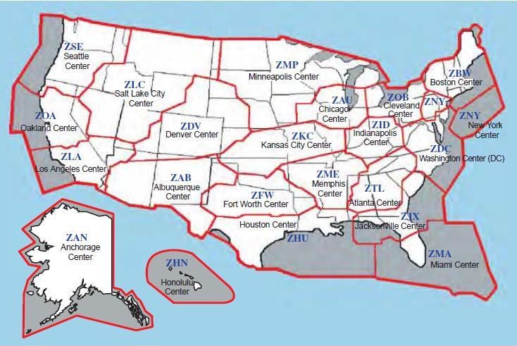
Air Route Traffic Control Center Services:
Issues route assignment (ARTCC coordinates based on your clearance)
May operate from Remote Center Air/Ground sites (RCAG) to cover distance
Verifies/assigns altitude
Provides traffic separation
Furnishes vectors
If ARTCC asks your intentions at the destination airport then they are trying to plan your descent to give you to approach who will vector you for your approaches
PILOT: "[location] center, [call sign], (level / climbing to / leaving / descending to)[altitude]"
Non-RADAR:
PILOT: "[location] center, [call sign], [position], [altitude], estimating [location], at [time]"
Direct Communications, Controllers and Pilots:
ARTCCs are capable of direct communications with IFR air traffic on certain frequencies
Maximum communications coverage is possible through the use of RCAG sites comprised of both VHF and UHF transmitters and receivers
These sites are located throughout the U.S. Although they may be several hundred miles away from the ARTCC, they are remoted to the various ARTCCs by land lines or microwave links
Since IFR operations are expedited through the use of direct communications, pilots are requested to use these frequencies strictly for communications pertinent to the control of IFR aircraft
Flight plan filing, en route weather, weather forecasts, and similar data should be requested through FSSs, company radio, or appropriate military facilities capable of performing these services
An ARTCC is divided into sectors
Each sector is handled by one or a team of controllers and has its own sector discrete frequency
As a flight progresses from one sector to another, the pilot is requested to change to the appropriate sector discrete frequency
Controller Pilot Data Link Communications (CPDLC) is a system that supplements air/ground voice communications
As a result, it expands two-way air traffic control air/ground communications capabilities
Consequently, the air traffic system's operational capacity is increased and any associated air traffic delays become minimized
A related safety benefit is that pilot/controller read-back and hear-back errors will be significantly reduced
The CPDLC's principal operating criteria are:
The CPDLC's principal operating criteria are:
Voice remains the primary and controlling air/ground communications means
Participating aircraft will need to have the appropriate CPDLC avionics equipment in order to receive uplink or transmit downlink messages
En Route CPDLC Initial Services offer the following services: Altimeter Setting (AS), Transfer of Communications (TOC), Initial Contact (IC), and limited route assignments, including airborne reroutes (ABRR), limited altitude assignments, and emergency messages
Altimeter settings will be uplinked automatically when appropriate after a Monitor TOC. Altimeter settings will also be uplinked automatically when an aircraft receives an uplinked altitude assignment below FL 180. A controller may also manually send an altimeter setting message
NOTE-When conducting instrument approach procedures, pilots are responsible to obtain and use the appropriate altimeter setting in accordance with 14 CFR Section 97.20. CPDLCissued altimeter settings are excluded for this purpose
Initial contact is a safety validation transaction that compares a pilot's initiated altitude downlink message with an aircraft's stored altitude in the ATC automation system. When an IC mismatch or Confirm Assigned Altitude (CAA) downlink time-out indicator is displayed in the Full Data Block (FDB) and Aircraft List (ACL), the controller who has track control of the aircraft must use voice communication to verify the assigned altitude of the aircraft, and acknowledge the IC mismatch/time-out indicator
Transfer of communications automatically establishes data link contact with a succeeding sector
Menu text transmissions are scripted nontrajectory altering uplink messages
The CPDLC Message Elements for the Initial Capabilities rollout are contained in TBL 5-3-1 through TBL 5-3-19, CPDLC Message Elements, in the Aeronautical Information Manual
NOTE-The FAA is not implementing ATN B1; the ATN B1 column in the tables is there for informational purposes only
Frequency Change Procedures:
As flights proceed along a route, pilots will move from one sector or ARTCC to another
The following phraseology will be used by controllers to effect a frequency change:
Example: "[Aircraft identification] contact [Facility name or location name and terminal function][Frequency] at [Time, fix, or altitude]"
Pilots are expected to maintain a listening watch on the transferring controller's frequency until the time, fix, or altitude specified. ATC will omit frequency change restrictions whenever pilot compliance is expected upon receipt
The following phraseology should be utilized by pilots for establishing contact with the designated facility:
When operating in a radar environment: On initial contact, the pilot should inform the controller of the aircraft's assigned altitude preceded by the words "level," or "climbing to," or "descending to," as appropriate; and the aircraft's present vacating altitude, if applicable
Exact altitude or flight level reports on initial contact provide ATC with information required prior to using Mode C altitude information for separation purposes
Exact altitude or flight level means to the nearest 100 foot increment
Pilot: "[Facility] center, [Aircraft identification], level [Altitude or Flight Level]"
Pilot: "[Facility] center, [Aircraft Identification], leaving [Exact Altitude or Flight Level], climbing to or descending to [Altitude of Flight Level]"
When operating in a non-radar environment:
On initial contact, the pilot should inform the controller of the aircraft's present position, altitude and time estimate for the next reporting point
Example:[Facility] center, [Aircraft Identification], [Position], [Altitude], estimating [Reporting Point] at [Zulu Time]"
After initial contact, when a position report will be made, the pilot should give the controller a complete position report
Example:[Facility] center, [Aircraft Identification], [Position], [Zulu Time], [Altitude], [Type of Flight Plan], [ETA and Name of Next Reporting Point], [The Name of the Next Succeeding Reporting Point], and [Remarks]"
At times controllers will ask pilots to verify that they are at a particular altitude
The phraseology used will be: Verify at Altitude"
In climbing or descending situations, controllers may ask pilots to "Verify assigned altitude as [Altitude]"
Pilots should confirm that they are at the altitude stated by the controller or that the assigned altitude is correct as stated
If this is not the case, they should inform the controller of the actual altitude being maintained or the different assigned altitude
Pilots should not take action to change their actual altitude or different assigned altitude to the altitude stated in the controllers verification request unless the controller specifically authorizes a change
ARTCC Radio Frequency Outage:
ARTCCs normally have at least one back-up radio receiver and transmitter system for each frequency, which can usually be placed into service quickly with little or no disruption of ATC service
Occasionally, technical problems may cause a delay but switchover seldom takes more than 60 seconds
When it appears that the outage will not be quickly remedied, the ARTCC will usually request a nearby aircraft, if there is one, to switch to the affected frequency to broadcast communications instructions
It is important, therefore, that the pilot wait at least 1 minute before deciding that the ARTCC has actually experienced a radio frequency failure
When such an outage does occur, the pilot should, if workload and equipment capability permit, maintain a listening watch on the affected frequency while attempting to comply with the following recommended communications procedures:
If two-way communications cannot be established with the ARTCC after changing frequencies, a pilot should attempt to recontact the transferring controller for the assignment of an alternative frequency or other instructions
When an ARTCC radio frequency failure occurs after two-way communications have been established, the pilot should attempt to reestablish contact with the center on any other known ARTCC frequency, preferably that of the next responsible sector when practicable, and ask for instructions
However, when the next normal frequency change along the route is known to involve another ATC facility, the pilot should contact that facility, if feasible, for instructions
If communications cannot be reestablished by either method, the pilot is expected to request communications instructions from the FSS appropriate to the route of flight
The exchange of information between an aircraft and an ARTCC through an FSS is quicker than relay via company radio because the FSS has direct interphone lines to the responsible ARTCC sector
Accordingly, when circumstances dictate a choice between the two, during an ARTCC frequency outage, relay via FSS radio is recommended
Cruise Clearance:
A cruise clearance can expedite your flight and help streamline the process of cruise, descent and approach
Most cruise clearances clear you direct to the next navaid or destination, operating at any altitude from the specified height down to the MEA
Pilots need not report leaving your altitude for descent, and you can be confident you're the only traffic in the area
Pilots are responsible for ensuring the MEA is met (as it changes along the route)
Pilots are automatically cleared for the approach at your destination, and your only obligation is to report "landing assured" or that you're executing the miss and going to plan B
This is a common procedure flying into non-tower airports on many of the mid-Pacific Islands, such as Majuro in the Marshalls and Tarawa in the Kiribatis, but it can work just as well in light traffic anywhere (i.e., sparsely populated or night)
Oakland Oceanic Flight Information Region (FIR):
The use of CPDLC and ADS-C in the Oakland Oceanic FIR (KZAK) is only permitted by Inmarsat, Iridium, and MTSAT customers. All other forms of data link connectivity are not authorized. Users must ensure that the proper data link code is filed in Item 10a of the ICAO FPL in order to indicate which satellite medium(s) the aircraft is equipped with. The identifier for Inmarsat is J5, the identifier for MTSAT is J6, and the identifier for Iridium is J7. If J5, J6, or J7 is not included in the ICAO FPL, then the LOGON will be rejected by KZAK and the aircraft will not be able to connect
New York Oceanic Flight Information Region (FIR):
The use of CPDLC and ADS-C in the New York Oceanic FIR (KZWY) is only permitted by Inmarsat and Iridium customers. All other forms of data link connectivity are not authorized. Users must ensure that the proper datalink code is filed in Item 10a of the ICAO FPL in order to indicate which satellite medium(s) the aircraft is equipped with. The identifier for Inmarsat is J5 and the identifier for Iridium is J7. If J5 or J7 is not included in the ICAO FPL, then the LOGON will berejected by KZWY and the aircraft will not be able to connect
Inflight Weather Advisory Broadcasts:
Weather Advisory Broadcasts:
ARTCCs broadcast a Severe Weather Forecast Alert (AWW), Convective SIGMET, SIGMET, AIRMET, Urgent Pilot Report, or CWA alert once on all frequencies, except emergency, when any part of the area described is within 150 miles of the airspace under their jurisdiction. These broadcasts advise pilots of the availability of hazardous weather advisories and to contact the nearest Flight Service facility for additional details
ATC: "Attention all aircraft, SIGMET Delta Three, from Myton to Tuba City to Milford, severe turbulence and severe clear icing below one zero thousand feet. Expected to continue beyond zero three zero zero zulu"
ATC: "Attention all aircraft, convective SIGMET Two Seven Eastern. From the vicinity of Elmira to Phillipsburg. Scattered embedded thunderstorms moving east at one zero knots. A few intense level five cells, maximum tops four five zero"
ATC: "Attention all aircraft, Kansas City Center weather advisory one zero three. Numerous reports of moderate to severe icing from eight to niner thousand feet in a three zero mile radius of St. Louis. Light or negative icing reported from four thousand to one two thousand feet remainder of Kansas City Center area"
Terminal control facilities have the option to limit the AWW, convective SIGMET, SIGMET, or CWA broadcast as follows: local control and approach control positions may opt to broadcast SIGMET or CWA alerts only when any part of the area described is within 50 miles of the airspace under their jurisdiction
Air Route Traffic Control CentersAir Route Traffic Control Centers
Conclusion:
Air Route Traffic Control Centers provide weather through on-staff National Weather Service Meteorologists, in coordination with the Aviation Weather Center