Aviation Routine Weather Report Background:
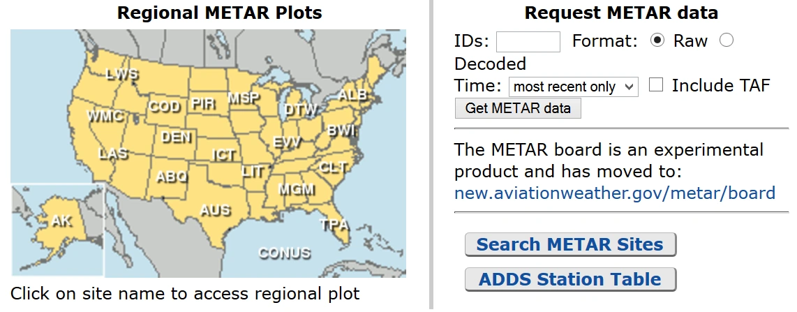
- Aviation Routine Weather Reports (METARs) provide a snapshot in time of terminal weather [Figure 1]
- The Aviation Weather Center provides METARS through its website, utilizing a query tool or java tool
- Although the METAR code is adopted worldwide, each country is allowed to make modifications or exceptions to the code for use in their particular country, e.g., the U.S.:
- Temperature and dew point are reported in degrees Celsius
- Visibility is reported in statute miles
- Runway Visual Range (RVR) is reported in feet
- Wind speed is reported in knots
- Altimeter settings are reported in inches of mercury
- The U.S reports prevailing visibility rather than lowest sector visibility
Aviation Routine Weather Report Issuance & Validity:
- Issued every hour, usually 55~59 past the hour
- Data may be up to 15 minutes old and should not be older
- Valid for 1 hour or until the next released report
Aviation Routine Weather Report Contents:
- The elements in the body of a METAR report are separated by a space
- The only exceptions are RVR, temperature, and dew point, which are separated by a solidus (/)
- When an element does not occur or is not observed, the preceding space and that element are omitted from that particular report
- A METAR report contains the following sequence of elements:
-
Element 1: Type of Report:
SPECI KDEN 041635Z 36008KT 10SM R28L/2600FT FEW090 FEW140 BKN220 23/10 A3015 RMK AO2 SLP143 VIRGA NE T00391072
- There are two types of reports: METARs and SPECIs
- METARs are routine reports
- SPECIs are special observations
- SPECIs are issued when there is a significant chance since the last METAR, warranting a special report
- There are two types of reports: METARs and SPECIs
-
Element 2: ICAO Station Identifier:
SPECI KDEN 041635Z 36008KT 10SM R28L/2600FT FEW090 FEW140 BKN220 23/10 A3015 RMK AO2 SLP143 VIRGA NE T00391072
- Every airport in the world is identified as a three-letter identifer
-
Continental United States ICAO Prefixes:
- In the contiguous 48 States, a "K" prefixes the 3-letter domestic station identifier (e.g., DXR is KDXR)
-
Outside Continental United States ICAO Prefixes:
- PA = Alaska (PANC for Anchorage Itl, AK)
- PH = Hawaii (PHNL for Honolulu Intl, HI)
- CU, CW, CY, CZ = Canada
- MM = Mexico
- Western Caribbean is "M" followed by the individual country's letter; i.e., Cuba is "MU;" Dominican Republic "MD;" the Bahamas "MY"
- Eastern Caribbean is "T" followed by the individual country's letter; i.e., Puerto Rico is "TJ"
- For a complete worldwide listing, see ICAO Document 7910, Location Indicators
-
Element 3: Forecast Times and Report Modifier:
SPECI KDEN 041635Z 36008KT 10SM R28L/2600FT FEW090 FEW140 BKN220 23/10 A3015 RMK AO2 SLP143 VIRGA NE T00391072
-
Date Time Group (DTG):
- Six-digit date/time group appended with Z to denote the time Coordinated Universal Time (UTC)
- The first two digits are the date, followed by two digits for the hour and two digits for minutes (dd/hh/mm)
- Example: 172345Z (the 17th day of the month at 2345Z)
- Observations are started no earlier than 15 minutes before reporting time
- Automated stations get data 10 minutes prior, but sky cover is gathered over the preceding 30 minutes
- Data with the greatest rate of change is evaluated last, assuring the most current data
- SPECI reports the time when the observation took place
-
Modifier:
- "AUTO" identifies a METAR/SPECI report as an automated weather report with no human intervention
- If "AUTO" is shown in the body of the report, the type of sensor equipment used at the station will be in the remarks
- AO1 for automated weather reporting stations without a precipitation discriminator
- AO2 for automated stations with a precipitation discriminator
- A precipitation discriminator can determine the difference between liquid and frozen/freezing precipitation
- The absence of "AUTO" indicates that a report was made manually by an observer or that an automated report had human augmentation/backup
- If "AUTO" is shown in the body of the report, the type of sensor equipment used at the station will be in the remarks
- COR indicates a corrected observation
- The DTG will be the time used in the observation corrected
- No modifier indicates human observer or automated system with human logged on for oversight functions
- "AUTO" identifies a METAR/SPECI report as an automated weather report with no human intervention
-
-
Element 4: Wind:
SPECI KDEN 041635Z 36008KT 10SM R28L/2600FT FEW090 FEW140 BKN220 23/10 A3015 RMK AO2 SLP143 VIRGA NE T00391072
- A five-digit group records wind (six digits if the speed is over 99 knots)
- The first three digits are the direction the wind is blowing from, in tens of degrees referenced to true north, or "VRB" if the direction is variable
- The next two-digits are the wind speed in knots, or if over 99 knots, the next three-digits
- If the wind is gusty, it is reported as a "G" after the speed followed by the highest gust reported
- The abbreviation "KT" follows, denoting the use of knots for wind speed
- Other countries use KM / MPH / MPS
- Reported as 2-minute averages
- Wind speed for the most recent 10 minutes determines gusts
- The maximum peak is reported using two or three-digits
- If the wind direction varies by 60° or more and speeds greater than 6 knots, a variable group consisting of the extremes of the wind direction separated by a "v" will follow the prevailing wind group
- If the wind direction is variable and the speed is 6 knots or less, replace wind direction with VRB, followed by wind speed in knots; or in rare cases when it is impossible to forecast a single wind direction, such as thunderstorms
- 27010KT: Wind from 270 at 10 knots
- WND 270V350: Wind variable 270 to 350
- 14020KTG30: Wind from 140 at 20 knots, gusting to 30 knots
- 00000KT: Winds calm
- 210103G130KT: Wind from 210° at 103 knots with gusts to 130 knots
- 32012G22KT 280V350: Wind 320 at 12 knots, gusting to 22, variable between 280 and 350°
- If the wind direction is variable by 60 degrees or more and the speed is greater than 6 knots, a variable group consisting of the extremes of the wind direction separated by a "v" will follow the prevailing wind group
- Peak Wind: Whenever the peak wind exceeds 25 knots, "PK WND" will be included in Remarks, e.g., PK WND 28045/1955 "Peak wind two eight zero at four-five occurred at one niner five five." If the hour can be inferred from the report time, only the minutes will be appended, e.g., PK WND 34050/38 "Peak wind three four zero at five zero occurred at three eight past the hour"
- Wind shift: Whenever a wind shift occurs, "WSHFT" will be included in remarks followed by the time the wind shift began, e.g., WSHFT 30 FROPA "Wind shift at three zero due to frontal passage"
- A five-digit group records wind (six digits if the speed is over 99 knots)
-
Element 5: Visibility, Weather, and Obstructions to Vision:
SPECI KDEN 041635Z 36008KT 10SM R28L/2600FT FEW090 FEW140 BKN220 23/10 A3015 RMK AO2 SLP143 VIRGA NE T00391072
- Prevailing visibility is measured in statue miles (SM)
- Example: 10SM
- Ten statute miles
- Example: 1/2SM
- One-half statute miles
- Example: 10SM
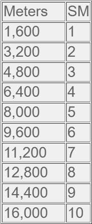
- Reported in meters outside of the U.S.
- Meters / 1600 = SM
- M is used to indicate less than one-quarter SM
- If visibility is less than 7 SM the weather/obstruction to vision is reported
- Tower/surface visibility: If either visibility (tower or surface) is below four statute miles, the lesser visibility is reported in the body of the report; the greater visibility is reported in remarks
- Automated visibility: Automated Surface Observat System/Aviation Weather Observation System (ASOS/AWOS) visibility stations will show visibility ten or greater than then miles as "10SM." AWOS visibility stations will show visibility less than 1/4 statute mile as "M1/4SM" and visibility ten or greater than ten miles as "10SM"
- Human observers augment automated sites to meet service level requirements can report 0, 1/16 SM, and 1/8 SM visibility increments
- Variable visibility: Variable visibility is reported in remarks (when rapid increase or decrease by 1/2 statute mile or more and the average prevailing visibility is less than three miles) e.g., VIS 1V2 "visibility variable between one and two"
- Sector visibility: Sector visibility is reported in remarks when it differs from the prevailing visibility, and either the prevailing or sector visibility is less than three miles
- Example: VIS N2 - visibility north two
- Civilian: forecasted prevailing visibility is reported in statute miles
- Military: Forecasted prevailing visibility is reported in meters and rounded down to the nearest reportable value
- Whenever the prevailing visibility is forecasted to be 9,000 meters or less (6 miles or less), the weather or obstructions to vision causing the reduced visibility will be included using the same notation as the METAR
- 9999 indicates 7 miles visibility or greater is forecasted (unlimited visibility)
- When appropriate, RVRs will follow immediately after the prevailing visibility
- If any significant weather or obstruction to vision is forecasted, it will be included after visibility using standard codes
- Omitted if no weather is present
- Prevailing visibility is measured in statue miles (SM)
-
Element 6: Runway Visual Range (RVR):
SPECI KDEN 041635Z 36008KT 10SM R28L/2600FT FEW090 FEW140 BKN220 23/10 A3015 RMK AO2 SLP143 VIRGA NE T00391072
- A 10-minute RVR evaluation in hundreds of feet
- A two-digit runway designator with a 4-digit value
- Example: R28L/2600FT
- Runway 28L has an RVR of 2600 feet
- Example: R27R/M1000V4000FT
- Runway two seven right R-V-R variable from less than one thousand to four thousand
- Example: R28L/2600FT
- Horizontal visibility as determined from instruments (transmissometer) located alongside and about 14' higher than runway centerline
- Calibrated with reference to the sighting of either high-intensity runway lights or the visual contrast of other targets
- RVR shall only be reported when the equipment is operational
- Reported whenever the prevailing visibility is 1 SM, or less/or the RVR is 6000' or less
- RVR measures in 200' increments to 3000'
- RVR measures in 500' increments above 3000'
- Encoded with an R followed by the two-digit runway and any R/L/C for the runway (right, left, center)
- A forward slash divides the runway and the RVR
- The RVR is appended with "FT" to indicate feet
- If variable, the two RVRs will be separated with a V
- "P" indicates an observed RVR is above the maximum value for this system (spoken as "more than"). "M" indicates an observed RVR is below the minimum value, which the system can determine (spoken as "less than")
- Reference the chart above for meters to SM converting
-
Element 7: Present Weather:
SPECI KDEN 041635Z 36008KT 10SM R28L/2600FT FEW090 FEW140 BKN220 23/10 A3015 RMK AO2 SLP143 VIRGA NE T00391072
- The weather as reported in the METAR code represents a significant change in the way weather is currently reported
- The weather is reported in the format: Intensity/Proximity/Descriptor/Precipitation/Obstruction to visibility/Other
-
Intensity:
- Intensity applies only to the first type of precipitation reported
- "-" denotes light, no symbol denotes moderate, and "+" denotes heavy
- Intensity applies only to the first type of precipitation reported
-
Proximity:
- Proximity applies to and is reported only for weather occurring in the vicinity of the airport (between 5 and 10 miles of the point(s) of observation)
- The letters "VC" (Intensity and "VC" will not appear together in the weather group) denote proximity
- Proximity applies to and is reported only for weather occurring in the vicinity of the airport (between 5 and 10 miles of the point(s) of observation)
-
Descriptor:
- These eight descriptors apply to the precipitation or obstructions to visibility:
- TS: thunderstorm
- DR: low drifting
- SH: showers
- MI: shallow
- FZ: freezing
- BC: patches
- BL: blowing
- PR: partial
- Although "TS" and "SH" are used with precipitation and may be preceded with an intensity symbol, the intensity still applies to the precipitation, not the descriptor
- These eight descriptors apply to the precipitation or obstructions to visibility:
-
Precipitation:
- There are nine types of precipitation in the METAR code:
- RA: rain
- DZ: drizzle
- SN: snow
- GR: hail (1/4" or greater)
- GS: small hail/snow pellets
- PL: ice pellets
- SG: snow grains
- IC: ice crystals (diamond dust)
- UP: unknown precipitation (automated stations only)
- There are nine types of precipitation in the METAR code:
-
Obstructions to visibility:
- Obscurations are any phenomena in the atmosphere, other than precipitation, that reduce horizontal visibility
- There are eight types of obscuration phenomena in the METAR code:
- FG: fog (vsby less than 5/8 mile)
- HZ: haze
- FU: smoke
- PY: spray
- BR: mist (vsby 5/8 - 6 miles)
- SA: sand
- DU: dust
- VA: volcanic ash
- Fog (FG) is observed or forecast only when the visibility is less than five-eighths of mile; otherwise mist (BR) is observed or forecast
-
Other:
- There are five categories of other weather phenomena:
- SQ: squall
- SS: sandstorm
- DS: duststorm
- PO: dust/sand whirls
- FC: funnel cloud
- +FC: tornado/waterspout
- There are five categories of other weather phenomena:
- Phenomena may be evaluated instrumentally, manually, or through a combination of methods
- VC indicates in the vicinity of 5 to 10 miles
- Any report beyond 10 miles will be in the remarks
- Intensity refers to precipitation, not a descriptor (TS or SH)
-
Element 8: Sky Condition:
SPECI KDEN 041635Z 36008KT 10SM R28L/2600FT FEW090 FEW140 BKN220 23/10 A3015 RMK AO2 SLP143 VIRGA NE T00391072
- The sky conditions describes the appearance of the sky, including cloud types/layers and sky coverage
- All sky cover heights are reported in hundreds of feet above the ground level (AGL)
- Layers are reported in ascending order up to the first overcast
- If the layers are below the station (mountainous stations), then "///" is used for height
- Reported in a 6-character group
- When the sky is partially obscured, the amount of sky cover hidden will be reported, and then a remark will give details
- When the sky is totally obscured, only VV will be reported
- For obscured sky:
- VV = vertical visibility
- VV is in hundreds of feet as well
- More than 1 layer may be reported
- Clouds may be followed by another modifier:
- T = towering
- CU = cumulus
- CB = cumulonimbus
- Sky condition is reported in the format: Amount/Height/(Type) or Indefinite Ceiling/Height
-
Amount:
- The amount of sky cover is reported in eighths of sky cover, using the contractions:
- SKC: clear (no clouds)
- SKC will be reported at manual stations
- CLR: clear (no clouds)
- CLR will be used at automated stations when no clouds below 12,000 feet are reported
- FEW: >0 to 2/8
- SCT: scattered (3/8s to 4/8s of clouds)
- BKN: broken (5/8s to 7/8s of clouds)
- OVC: overcast (8/8s clouds)
- CB: Cumulonimbus when present
- TCU: Towering cumulus when present
- SKC: clear (no clouds)
- Note that a ceiling layer is not designated in the METAR code
- For aviation purposes, the ceiling is the lowest broken or overcast layer or vertical visibility into an obscuration. Also, there is no provision for reporting thin layers in the METAR code. When clouds are thin, that layer must be reported as if it were opaque
- The amount of sky cover is reported in eighths of sky cover, using the contractions:
-
Height:
- Cloud bases are reported with three digits in hundreds of feet above ground level (AGL)
- An automated station cannot report clouds above 12,000 feet)
-
Type:
- If Towering Cumulus Clouds (TCU) or Cumulonimbus Clouds (CB) are present, they are reported after the height, which represents their base
-
Vertical Visibility (indefinite ceiling height):
- The height into an indefinite ceiling is preceded by "VV" and followed by three digits indicating the vertical visibility in hundreds of feet
- This layer indicates total obscuration
-
Obscurations:
- Obscurations are when ground-based phenomena partially obscure the sky and are reported by the amount of obscuration, as FEW, SCT, BKN followed by three zeros (000)
- In remarks, the obscuring phenomenon precedes the amount of obscuration and three zeros
-
Layers:
- When sky conditions include a layer aloft, other than clouds, such as smoke or haze, the remarks describe the type of phenomena, sky cover, and height
-
Variable Ceiling:
- When a ceiling is below three thousand and is variable, the remark "CIG" is used, followed by the lowest and highest ceiling heights separated by a "V"
-
Second Site Sensor:
- When an automated station uses meteorological discontinuity sensors, remarks identify the site-specific sky conditions which differ and are lower than conditions reported in the body
-
Variable Cloud Layer:
- When a layer is varying in sky cover, remarks will show the variability range
- If there is more than one cloud layer, the variable layer will be identified by including the layer height
-
Significant Clouds:
- When significant clouds are observed, they are shown in remarks, along with the specified information as shown below:
- Cumulonimbus (CB), or Cumulonimbus Mammatus (CBMAM), distance (if known), direction from the station, and direction of movement, if known. If the clouds are beyond 10 miles from the airport, DSNT will indicate distance
- Towering Cumulus (TCU), location, (if known), or direction from the station
- Altocumulus Castellanus (ACC), Stratocumulus Standing Lenticular (SCSL), Altocumulus Standing Lenticular (ACSL), Cirrocumulus Standing Lenticular (CCSL) or rotor clouds, describing the clouds (if needed) and the direction from the station
- When significant clouds are observed, they are shown in remarks, along with the specified information as shown below:
-
Element 9: Temperature/Dew Point:
SPECI KDEN 041635Z 36008KT 10SM R28L/2600FT FEW090 FEW140 BKN220 23/10 A3015 RMK AO2 SLP143 VIRGA NE T00391072
- Temperature and dew point are reported in two, two-digit groups in degrees Celsius, separated by a solidus (/)
- Sub-zero values are prefixed with an M
- If the temperature is available, but the dew point is missing, the temperature is shown, followed by a (/)
- If the temperature is missing, the group is omitted from the report
- To convert between Celsius and Fahrenheit, visit the conversion page
-
Element 10: Altimeter:
SPECI KDEN 041635Z 36008KT 10SM R28L/2600FT FEW090 FEW140 BKN220 23/10 A3015 RMK AO2 SLP143 VIRGA NE T00391072
- Altimeter setting (in U.S. reports) is always prefixed with an A
- Indicates inches of mercury reported using four-digits
-
Element 11: Remarks:
SPECI KDEN 041635Z 36008KT 10SM R28L/2600FT FEW090 FEW140 BKN220 23/10 A3015 RMK AO2 SLP143 VIRGA NE T00391072
- Noted with the term RMK
- There are two categories of remarks:
- Automated, manual, and plain language
- Additive and automated maintenance
-
Automated, Manual, and Plain Language:
- This group of remarks may be generated from either manual or automated weather reporting stations and generally elaborate on parameters reported in the body of the report
- Parameters include:
- Volcanic eruptions
- Tornado, Funnel Cloud, Waterspout
- Station Type (AO1 or AO2)
- PK WND
- WSHFT (FROPA)
- TWR VIS or SFC VIS
- VRB VIS
- Sector VIS
- VIS @ 2nd Site
- Lightning:
- When observing lightning at a manual location, the report includes the frequency and location
- When automated lighting systems such as the Automated Lightning Detection and Reporting System (ALDARS) detects cloud-to-ground lightning:
- Within 5 nautical miles (NM) of the Airport Reference Point (ARP), it is reported as "TS" in the body of the report with no remark;
- Between 5 and 10 NM of the ARP, it is reported as "VCTS" in the body of the report with no remark;
- Beyond ten but less than 30 NM of the ARP, it is reported in remarks as "DSNT" followed by the direction from the ARP
- Beginning/Ending of Precipitation/TSTM (Thunderstorms)
- TSTM Location MVMT
- Hailstone Size (GR)
- Virga
- Virga is a weather phenomenon with "NE" signaling it is located to the northeast of the reporting station
- VRB CIG (height)
- Obscuration
- VRB Sky Condition
- Significant Cloud Types
- Ceiling Height 2nd Location
- PRESFR (Pressure Falling Rapidly), PRESRR (Pressure Rising Rapidly)
- Sea-Level Pressure
- If the number following "SLP" is less than 7, add a prefix of 10, for example, SLP143 = 1014.3 mb
- If the number following "SLP" is 7 or higher, add a prefix of 9, for example, SLP 743 = 974.3 mb
- ACFT Mishap (not transmitted)
- NOSPECI
- SNINCR (Snow Increasing)
- Other SIG Info
-
Additive and Automated Maintenance:
-
Precipitation: - Precipitation may be provided on intervals of hourly, 3, 6, and/or 24-hours
- Note the prefix "P" is only uesd for the first reading, if multiple hour interval readings are provided
- Hourly Precipitation
- RAE20UPB25 signifies rain ("RA") ended ("E") 20 minutes past the hour and unknown precipitation began 25 minutes after the hour
- A number 0 after the ("P") signifies the amount of precipitation that fell over the past hour, for example, P0001 is 0.01 inches over the past hour
- 3- and 6-Hour Precipitation Amount
- A number 6 after the ("P") signifies the amount of precipitation that fell over the past 6-hours, for example, P60032 is 0.32 inches over the past 6-hours
- 24-Hour Precipitation
- A number 7 after the ("P") signifies the amount of precipitation that fell over the past 24-hours, for example, P70289 is 2.89 inches over the past 24-hours
- Snow Depth on Ground
- Water Equivalent of Snow
- Cloud Type
- Duration of Sunshine
-
Temperature: - Temperature may be provided on intervals of hourly, 6, and/or 24-hours
- Note the prefix "T" is only used for the first reading, if multiple hour interval readings are provided
- Hourly Temperature/Dew Point (Tenths)
- If the first number for temperature is a 0, the temperature is positive, for example, T00391072 = 3.9°C
- If the first number for dew point is a 1, the temperature is negative, for example , T00391072 = -7.2°C
- 6-Hour Maximum Temperature
- If the first number is a 10, it signifies the highest temperature int he past 6-hours, for example, 10079 = 7.9°C maximum
- 6-Hour Minimum Temperature
- If the first number is a 20, it signifies the highest temperature int he past 6-hours, for example, 20018 = 1.8°C minimum
- 24-Hour Maximum/Minimum Temperature
- Pressure Tendency
- PRESRR signifies pressure ("PRES") is rising rapidly ("RR")
- A number with a prefix of "5" indicates barometric pressure tendancy within the past 3-hours
- If the number following the 5 is between 1 and 10, with 1 meaning rising rapidly, 5 meaning steady, and 10 meaning dropping rapidly
- The final three digits represent by how many hectopasals the pressure is changing, for example, 52040 means the pressure is rose rapidly by 4.0 hectopascals over the past 3-hours
- Sensor Status: PWINO (Precipitation Identifier Information Not Available), FZRANO (Freezing Rain Information Not Available), TSNO (Thunderstorm Information Not Available), RVRNO (RVR Information Not Available), PNO (Precipitation Amount Unavailable), VISNO (Visibility Information Not Available)
- Maintenance being required is signified as a $
-
- Remarks include clarifying or augmented data
- Except for precipitation, phenomena located within five statute miles of the point of observation is reported as at the station
- Phenomena between 5 and 10 statute miles will be reported in the vicinity, "VC"
- Precipitation not occurring at the point of observation but within 10 statute miles is also reported as in the vicinity, "VC"
- Phenomena beyond ten statute miles will be shown as distant, "DSNT"
- Distances are in statute miles except for automated lightning remarks which are in nautical miles
- Movement of clouds or weather will be indicated by the direction toward, which the phenomenon is moving
Reporting Prevailing Visibility:
- Surface (horizontal) visibility is reported in METAR reports in terms of statute miles and increments thereof; e.g., 1/16, 1/8, 3/16, 1/4, 5/16, 3/8, 1/2, 5/8, 3/4, 7/8, 1, 1 1/8, etc. (Visibility reported by an un-augmented automated site is reported differently than in a manual report, i.e., ASOS/AWOS: 0, 1/16, 1/8, 1/4, 1/2, 3/4, 1, 1 1/4, 1 1/2, 1 3/4, 2, 2 1/2, 3, 4, 5, etc., AWOS: M1/4, 1/4, 1/2, 3/4, 1, 1 1/4, 1 1/2, 1 3/4, 2, 2 1/2, 3, 4, 5, etc.) Visibility is determined through the ability to see and identify preselected and prominent objects at a known distance from the usual point of observation. Visibilities that are determined to be less than 7 miles identify the obscuring atmospheric condition; e.g., fog, haze, smoke, etc., or combinations thereof
- Prevailing visibility is the greatest visibility equaled or exceeded throughout at least one-half of the horizon circle, not necessarily contiguous. Segments of the horizon circle which may have significantly different visibility are reported in the remarks section of the weather report; i.e., "the southeastern quadrant of the horizon circle may be determined to be 2 miles in mist while the remaining quadrants are determined to be 3 miles in mist"
- When the prevailing visibility at the usual point of observation, or the tower level, is less than 4 miles, certificated tower personnel will take visibility observations in addition to those taken at the usual point of observation. The lower of these two values becomes the prevailing visibility for aircraft operations
Amazon Alexa Aviation Weather Tools:
- Through Amazon's Alexa, you can enable METAR skills with apps like:
Aviation Routine Weather Report Knowledge Quiz:
Conclusion:
- The adage "If you read it, it's true; if you hear it, it's magnetic" applies to METARs
- Winds from a METAR report as "true," which means it must be converted to magnetic if used for reference to a runway
- For more information, a paper copy of Aviation Weather Services: FAA Advisory Circular 00-45H, Change 1&2 (FAA Handbooks series) [Amazon] is available for purchase
- A digital copy of Advisory Circular (00-45), Aviation Weather Services is available from the FAA's website
- See also:
- Still looking for something? Continue searching:
References:
- Federal Aviation Administration (FAA-H-8083-28) Aviation Weather Handbook
- Advisory Circular (00-6), Aviation Weather
- Advisory Circular (00-45), Aviation Weather Services (7.2) Aviation Routine Weather Report (METAR)
- Aeronautical Information Manual (7-1-15) Reporting Preveiling Visibility
- Aeronautical Information Manual (7-1-16) Estimating Intensity of Rain and Ice Pellets
- Aeronautical Information Manual (7-1-17) Estimating Intensity of Snow or Drizzle (Based on Visibility)
- Aeronautical Information Manual (7-1-28) Key to Aerodrome Forecast (TAF) and Aviation Routine Weather Report (METAR)
- Aeronautical Information Manual (7-1-29) International Civil Aviation Organization (ICAO) Weather Formats
- Air Force Pamphlet (11-238) Aircrew Quick Reference to METAR and TAF Codes
- AOPA - Alexa, Do You Speak Pilot?
- Aviation Weather.gov - METARs
- Federal Aviation Administration - Pilot/Controller Glossary
- Flight Information Handbook
- National Weather Service Weather Forecast Office