Inflight Weather Advisories Issuance:
- Inflight aviation weather advisories are issued based on specific criteria (discussed below)
- Inflight aviation weather advisories in the conterminous U.S. are issued by several different sources:
- The Aviation Weather Center (AWC) in Kansas City, Missouri, as well as 20 Center Weather Service Units (CWSU) associated with ARTCCs
- AWC also issues advisories for portions of the Gulf of Mexico, Atlantic and Pacific Oceans, which are under the control of ARTCCs with Oceanic flight information regions (FIRs)
- For the Hawaiian Islands and a large portion of the Pacific Ocean, In-flight Weather Advisories are issued by the Weather Forecast Office (WFO) in Honolulu
- In Alaska, In-flight Weather Advisories are issued by the Alaska Aviation Weather Unit (AAWU) along with the Anchorage CWSU
- All heights are referenced MSL, except in the case of ceilings (listed as "CIG") which indicates AGL
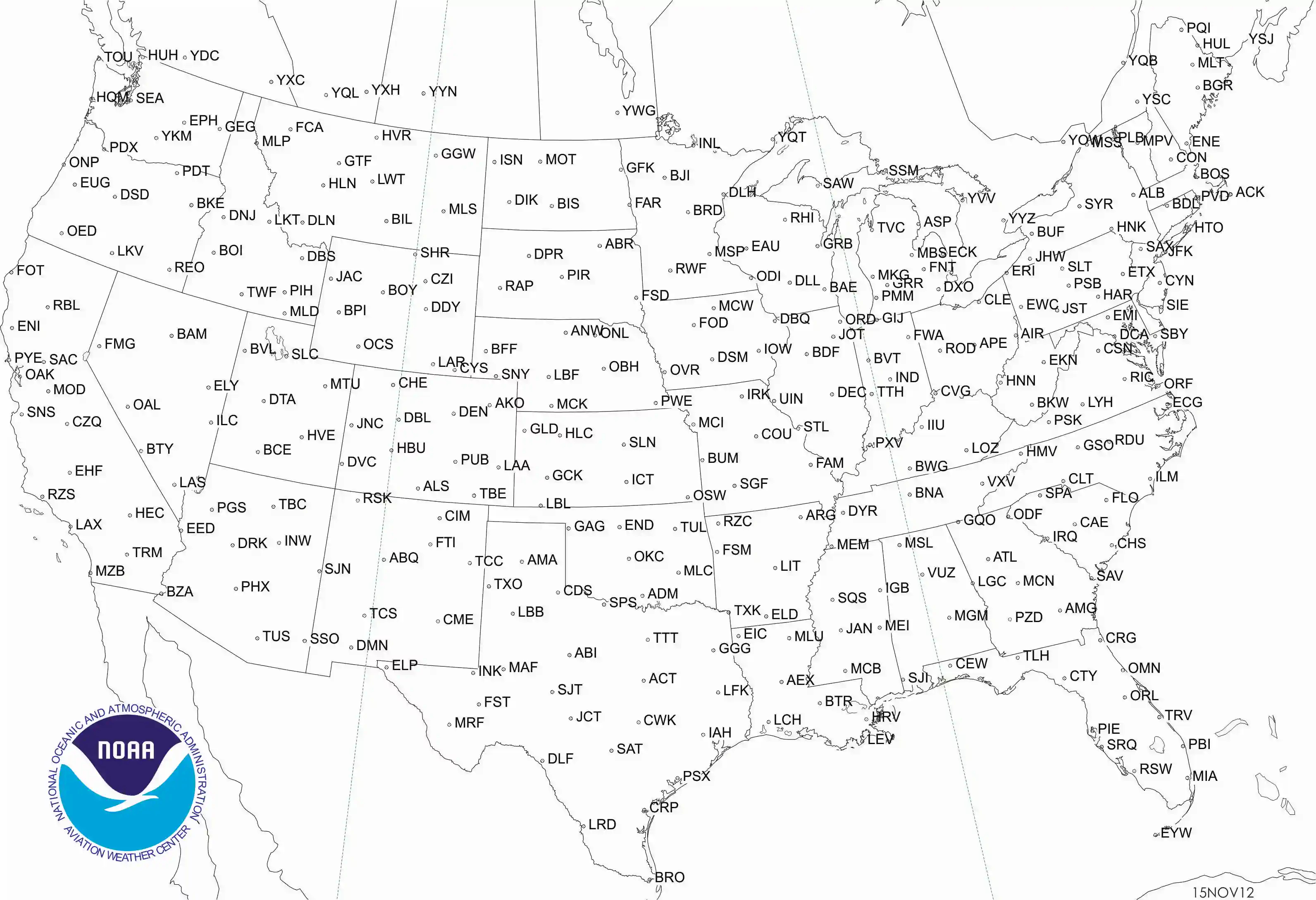
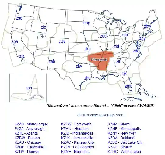
- SIGMETs/AIRMET text products for the CONUS are issued corresponding to geographic location Figure 1]
- No AIRMETs are issued for U.S. FIRs in the the Gulf of Mexico, Caribbean, Western Atlantic and Pacific Oceans
Inflight Weather Advisories Validity:
- Validity will vary depending on the type of inflight weather advisory:
- AIRMET are valid for a maximum of 6 hours
- Alaska AIRMETs are valid for up to 8 hours
- SIGMETs are valid for a maximum of 4 hours
- Tropical Cyclones and Volcanic Ash Cloud SIGMETs are valid for up to 6 hours
- Convective SIGMETs are valid for a maximum of 2 hours
- The G-AIRMET is issued over the CONUS every 6 hours, valid at 3-hour increments through 12 hours with optional forecasts possible during the first 6 hours
- The first 6 hours of the G-AIRMET correspond to the 6-hour period of the AIRMET
Airman Meteorological Information:
- AIRman's METeorological products are issued corresponding to the Area Forecasts (FA) areas shown in Figure 3, 4 & 5]
- Considered to be widespread because they must be affecting or be forecast to affect an area of at least 3000 square miles at any one time
- However, if the total area to be affected during the forecast period is very large, it could be that in actuality only a small portion of this total area would be affected at any one time
- These reports do not take into account terrain such as mountains or bodies of water which could impact the forecasted weather
- AIRMETs (WAs) are advisories of significant weather phenomena but describe conditions at intensities lower than those which require the issuance of SIGMETs
- AIRMETs are intended for dissemination to all pilots in the preflight and en route phase of flight to enhance safety
- AIRMET information are issued in two formats:
- A textual bulletin (WA), or
- Graphical report (G-AIRMET)
- AIRMETs contain details about IFR, extensive mountain obscuration, turbulence, strong surface winds, icing, and freezing levels
Text AIRMET (WA):
- AIRMET text (WA) products are issued corresponding to the Area Forecast (FA) areas described in Figure 3, 4 & 5]
- Considered to be widespread because they must be affecting or be forecast to affect an area of at least 3,000 square miles at any one time
- However, if the total area to be affected during the forecast period is very large, it could be that in actuality only a small portion of this total area would be affected at any one time
- AIRMETs (text) are issued every 6 hours, beginning at 0245 UTC with Graphical AIRMETs issued on schedule
- After the first issuance each day, scheduled or unscheduled bulletins are numbered sequentially for easier identification
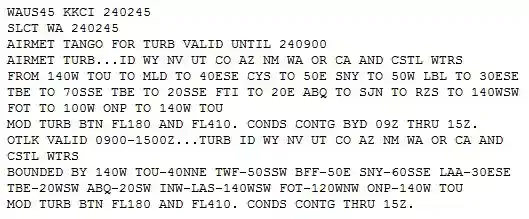
There are three types AIRMETs:
-
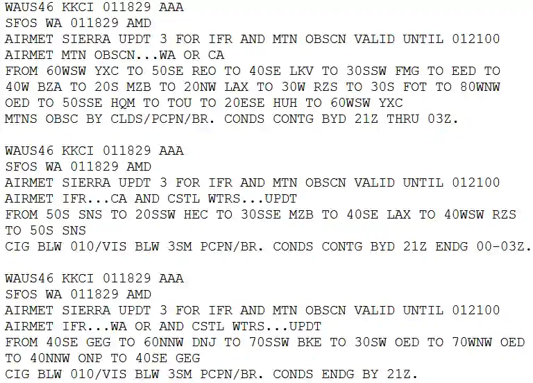
AIRMET Sierra:
- AIRMET Sierra describes IFR conditions and/or extensive mountain obscuration
- For operations under Instrument Flight Rules (IFR)
- Ceilings less than 1000' and/or visibility less than 3 miles affecting over 50% of an area at one time
-
AIRMET Tango:
- AIRMET Tango describes moderate turbulence, sustained surface winds of 30 knots or greater, and/or non-convective low-level wind shear
-
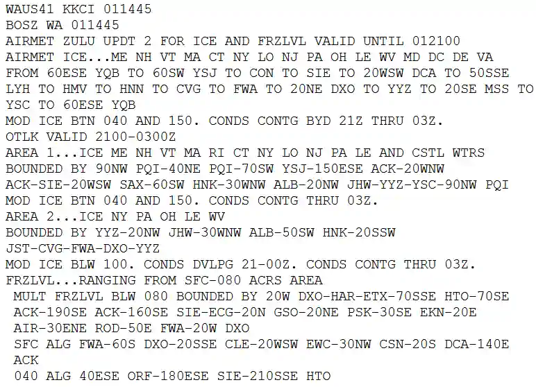
AIRMET Zulu:
- AIRMET Zulu describes moderate icing and provides freezing level heights
Graphical AIRMETs (G-AIRMETs):
- Graphical AIRMETs (G-AIRMETs) are graphical forecasts of en-route weather hazards valid at discrete times no more than 3 hours apart for a period of up to 12 hours into the future
- Example: 00, 03, 06, 09, and 12 hours
- Additional forecasts may be inserted during the first 6 hours
- Example: 01, 02, 04, and 05
- 00 hour represents the initial conditions, and the subsequent graphics depict the area affected by the particular hazard at that valid time
- Forecasts valid at 00 through 06 hours correspond to the text AIRMET bulletin
- Forecasts valid at 06 through 12 hours correspond to the text bulletin outlook
- G-AIRMET depicts the following en route aviation weather hazards:
- Instrument flight rule conditions (ceiling greater than 1000' and/or surface visibility greater than 3 miles)
- Mountain obscuration
- Icing
- Freezing level
- Turbulence
- Low level wind shear (LLWS)
- Strong surface winds
- G-AIRMETs are snap shots at discrete time intervals as defined above
- The text AIRMET is the result of the production of the G-AIRMET, but provided in a time smear for a 6 hr valid period
- G-AIRMETs provide a higher forecast resolution than text AIRMET products
- Since G-AIRMETs and text AIRMETs are created from the same forecast "production" process, there exists perfect consistency between the two
- Using the two together will provide clarity of the area impacted by the weather hazard and improve situational awareness and decision-making
- Interpolation of time periods between G-AIRMET valid times:
- Users must keep in mind when using the G-AIRMET, that if a 00 hour forecast shows no significant weather and a 03 hour forecast shows hazardous weather, they must assume a change is occurring during the period between the two forecasts
- It should be taken into consideration that the hazardous weather starts immediately after the 00 hour forecast, unless there is a defined initiation or ending time for the hazardous weather
- The same would apply after the 03 hour forecast
- The user should assume the hazardous weather condition is occurring between the snap shots, unless informed otherwise
- Example: if a 00 hour forecast shows no hazard, a 03 hour forecast shows the presence of hazardous weather, and a 06 hour forecast shows no hazard, the user should assume the hazard exists from the 0001 hour to the 0559 hour time period
- Graphical AIRMETs (G-AIRMETs) are graphical forecasts of en-route weather hazards valid at discrete times no more than 3 hours apart for a period of up to 12 hours into the future
Significant Meteorological Information:
- SIGnificant METeorological information products are issued corresponding to the Area Forecasts (FA) areas shown in Figure 3, 4 & 5]
- Issued as required to advise of weather that is potentially hazardous to all aircraft
- Only SIGMETs for the CONUS are for non-convective weather
- The U.S. issues a special category of SIGMETs for convective weather called Convective SIGMETs
- Considered to be widespread because they must be affecting or be forecast to affect an area of at least 3000 square miles at any one time
- However, if the total area to be affected during the forecast period is very large, it could be that in actuality only a small portion of this total area would be affected at any one time
- SIGMETS can be identified by an alphabetic designator from November through Yankee (excluding Sierra and Tango):
- Sierra, Tango, and Zulu are reserved for AIRMET text [WA] products; G-AIRMETS do not use the Sierra, Tango, or Zulu designators
- The first issuance of a SIGMET will be labeled as UWS (Urgent Weather SIGMET)
- Subsequent issuances are at the forecaster's discretion
- Issuance for the same phenomenon will be sequentially numbered, using the original designator until the phenomenon ends
- For example, the first issuance in the Chicago (CHI) FA area for phenomenon moving from the Salt Lake City (SLC) FA area will be SIGMET Papa 3, if the previous two issuances, Papa 1 and Papa 2, had been in the SLC FA area
- No two different phenomena across the country can have the same alphabetic designator at the same time
- Example of a SIGMET:
- BOSR WS 050600
- SIGMET ROMEO 2 VALID UNTIL 051000
- ME NH VT
- FROM CAR TO YSJ TO CON TO MPV TO CAR MOD TO OCNL SEV TURB BLW 080 EXP DUE TO STG NWLY FLOW. CONDS CONTG BYD 1000Z
- Contents:
In the conterminous U.S., SIGMETs are issued when the following phenomena occur or are expected to occur:
- Severe icing not associated with thunderstorms
- Severe or extreme turbulence or clear air turbulence (CAT) not associated with thunderstorms
- Dust storms or sandstorms lowering surface or in-flight visibilities to below 3 miles
- Volcanic ash
In Alaska and Hawaii, SIGMETs are also issued for:
- Tornadoes
- Lines of thunderstorms
- Embedded thunderstorms
- Hail greater than or equal to 3/4 inch in diameter
Outside the conterminous U.S.:
- Three NWS offices have been designated by ICAO as Meteorological Watch Offices (MWOs)
- These offices are responsible for issuing SIGMETs for designated areas outside the CONUS that include Alaska, Hawaii, portions of the Atlantic and Pacific Oceans, and the Gulf of Mexico
- The offices which issue international SIGMETs are:
- The AWC in Kansas City, Missouri
- The AAWU in Anchorage, Alaska
- The WFO in Honolulu, Hawaii
- Like the CONUS SIGMETs, SIGMETs for outside the CONUS are also identified by an alphabetic designator from Alpha through Mike and are numbered sequentially until that weather phenomenon ends
- The criteria for an international SIGMET are:
- Thunderstorms occurring in lines, embedded in clouds, or in large areas producing tornadoes or large hail
- Tropical cyclones
- Severe icing
- Severe or extreme turbulence
- Dust storms and sandstorms lowering visibilities to less than 3 miles
- Volcanic ash
- Example of SIGMET Outside the U.S.:
- WSNT06 KKCI 022014
- SIGA0F
- KZMA KZNY TJZS SIGMET FOXTROT 3 VALID
- 022015/030015 KKCI- MIAMI OCEANIC FIR NEW
- YORK OCEANIC FIR SAN JUAN FIR FRQ TS WI AREA
- BOUNDED BY 2711N6807W 2156N6654W 2220N7040W
- 2602N7208W 2711N6807W. TOPS TO FL470. MOV NE
- 15KT. WKN. BASED ON SAT AND LTG OBS
- MOSHER
- Three NWS offices have been designated by ICAO as Meteorological Watch Offices (MWOs)
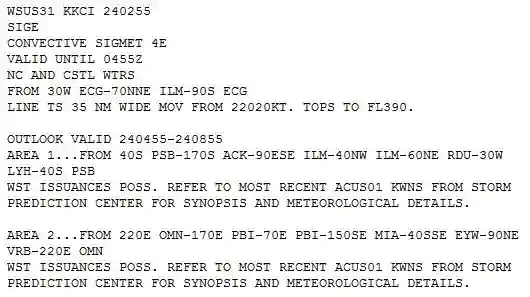
Convective SIGMETs:
- Convective SIGMETS (also known internationally as SIGMET for Convection) are text/graphical reports are issued for the contiguous U.S
- Any convective SIGMET implies severe or greater turbulence, severe icing, and low-level wind shear issued for any convective situation that the forecaster feels is hazardous to all categories of aircraft
- Convective SIGMET bulletins are issued for the western (W), center (C), and eastern (E) United States
- Convective SIGMETs are not issued for Alaska or Hawaii
- The areas are separated at 87° and 107° west longitude with sufficient overlap to cover most cases when the phenomenon crosses the boundaries
- If no criteria meeting convective SIGMET requirements are observed or forecasted, the message "CONVECTIVE SIGMET...NONE" will be issued at H+55 for each area
- Individual convective SIGMETs for each area (W, C, E) are numbered sequentially from number one each day, beginning at 00Z
- Bulletins are issued hourly at H+55
- If conditions warrant, special bulletins are issued at any time as required and updated at H+55
- If no criteria meeting convective SIGMET requirements are observed or forecasted, the message "CONVECTIVE SIGMET... NONE" will be issued for each area at H+55
- Individual convective SIGMETs for each area (W, C, E) are numbered sequentially from number one each day, beginning at 00Z
- A convective SIGMET for a continuing phenomenon will be reissued every hour at H+55 with a new number
- The text of the bulletin consists of either an observation and a forecast or just a forecast
- Contents:
- Convective SIGMETs are issued in the conterminous U.S. for any of the following:
- Severe thunderstorms due to:
- Surface winds greater than or equal to 50 knots
- Hail at the surface greater than or equal to 3/4 inches in diameter
- Tornadoes
- Embedded Thunderstorms
- A line of thunderstorms
- Thunderstorms that produce precipitation levels greater than or equal to heavy-intensity precipitation, affecting 40% or more of an area at least 3,000 square miles
- Severe thunderstorms due to:
- Convective SIGMETs are issued in the conterminous U.S. for any of the following:
- Example:
- CONVECTIVE SIGMET 44C
- VALID UNTIL 1455Z
- AR TX OK
- FROM 40NE ADM-40ESE MLC-10W TXK-50WNW
- LFK-40ENE SJT-40NE ADM
- AREA TS MOV FROM 26025KT. TOPS ABV FL450
- OUTLOOK VALID 061455-061855
- FROM 60WSW OKC-MLC-40N TXK-40WSW
- IGB-VUZ-MGM-HRV-60S BTR-40N
- IAH-60SW SJT-40ENE LBB-60WSW OKC
- WST ISSUANCES EXPD. REFER TO MOST RECENT
- ACUS01 KWNS FROM STORM PREDICTION CENTER
- FOR SYNOPSIS AND METEOROLOGICAL DETAILS
Watch Notification Messages:
- The Storm Prediction Center (SPC) in Norman, OK, issues Watch Notification Messages to provide an area threat alert for forecast organized severe thunderstorms that may produce tornadoes, large hail, and/or convective damaging winds within the CONUS
- SPC issues three types of watch notification messages:
- Aviation Watch Notification Messages
- Public Severe Thunderstorm Watch Notification Messages
- Public Tornado Watch Notification Messages
- It is important to note the difference between a Severe Thunderstorm (or Tornado) Watch and a Severe Thunderstorm (or Tornado) Warning
- A watch means severe weather is possible during the next few hours, while a warning means that severe weather has been observed, or is expected within the hour
- Only the SPC issues Severe Thunderstorm and Tornado Watches, while only NWS Weather Forecasts Offices issue Severe Thunderstorm and Tornado Warnings
The Aviation Watch Notification Message:
- The Aviation Watch Notification Message product is an approximation of the area of the Public Severe Thunderstorm Watch or Public Tornado Watch
- The area may be defined as a rectangle or parallelogram using VOR navigational aides as coordinates
- The Aviation Watch Notification Message was formerly known as the Alert Severe Weather Watch Bulletin (AWW)
- The NWS no longer uses that title or acronym for this product
- The NWS uses the acronym SAW for the Aviation Watch Notification Message, but retains AWW in the product header for processing by weather data systems
Public Severe Thunderstorm Watch Notification Messages:
- Public Severe Thunderstorm Watch Notification Messages describe areas of expected severe thunderstorms
- Severe thunderstorm criteria are 1-inch hail or larger and/or wind gusts of 50 knots [58 mph] or greater
- A Public Severe Thunderstorm Watch Notification Message contains the area description and axis, the watch expiration time, a description of hail size and thunderstorm wind gusts expected, the definition of the watch, a call to action statement, a list of other valid watches, a brief discussion of meteorological reasoning and technical information for the aviation community
- Public Severe Thunderstorm Watch Notification Messages describe areas of expected severe thunderstorms
Public Tornado Watch Notification Messages:
- Public Tornado Watch Notification Messages describe areas where the threat of tornadoes exists
- A Public Tornado Watch Notification Message contains the area description and axis, watch expiration time, the term "damaging tornadoes," a description of the largest hail size and strongest thunderstorm wind gusts expected, the definition of the watch, a call to action statement, a list of other valid watches, a brief discussion of meteorological reasoning and technical information for the aviation community
- SPC may enhance a Public Tornado Watch Notification Message by using the words "THIS IS A PARTICULARLY DANGEROUS SITUATION" when there is a likelihood of multiple strong (damage of EF2 or EF3) or violent (damage of EF4 or EF5) tornadoes
- Public severe thunderstorm and tornado watch notification messages were formerly known as the Severe Weather Watch Bulletins (WW)
- The NWS no longer uses that title or acronym for this product but retains WW in the product header for processing by weather data systems
- Status reports are issued as needed to show progress of storms and to delineate areas no longer under the threat of severe storm activity
- Cancellation bulletins are issued when it becomes evident that no severe weather will develop or that storms have subsided and are no longer severe
Center Weather Advisories (CWAs):
- A Center Weather Advisory is an unscheduled, flow control aviation warning for use by air traffic/air crews to anticipate and avoid adverse weather conditions in the en-route and terminal environments [Figure 1]
- As its name would suggest, it is a product of a center and not the National Weather Service
- By nature of its short lead time, the CWA is not a flight planning product
- It is generally a "nowcast" for conditions beginning within the next two hours
-
CWA Issuance
- As a supplement to an existing SIGMET, Convective SIGMET or AIRMET
- When an Inflight Advisory has not been issued but observed or expected weather conditions meet SIGMET/AIRMET criteria based on current pilot reports and reinforced by other sources of information about existing meteorological conditions
- When observed or developing weather conditions do not meet SIGMET, Convective SIGMET, or AIRMET criteria; e.g., in terms of intensity or area coverage, but current pilot reports or other weather information sources indicate that existing or anticipated meteorological phenomena will adversely affect the safe flow of air traffic within the ARTCC area of responsibility
- The following example is a CWA issued from the Kansas City, Missouri, ARTCC:
- ZKC3 CWA 032140 ZKC CWA 301 VALID UNTIL 032340 ISOLD SVR TSTM over KCOU MOVG SWWD 10 KTS ETC
- The "3" after ZKC in the first line denotes this CWA has been issued for the third weather phenomena to occur for the day. The "301" in the second line denotes the phenomena number again (3) and the issuance number (01) for this phenomena. The CWA was issued at 2140Z and is valid until 2340Z
- Found at https://www.aviationweather.gov/cwamis
-
CWA Validity:
- Issued as required
- Valid for 2 hours
- Not for use in flight planning
- Reflects actual or short range forecasts expected to begin within 2 hours
-
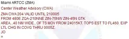
Translation:
- Location: ZMA (Miami) ARTCC
- Issuance occurrence: 204, phenomenon number (2) with the (04)th issue
- Validity: valid until the 21st day at 0005Z
- Some advisories may include an issuance time
- Area: based off of defined points and distances from them to form a geographic area
- Description: varies by report but the example talks about 40 NM wide area of thunder storms moving from the south west at 15 knots. Tops are estimated to be at 46,000' with little expected change in coverage through 0005Z
Conclusion:
- Only AIRMETs are scheduled leaving other inflight weather advisories to be issued as needed
- For more information on inflight Weather Broadcasts, visit the ARTCC page
- For more information, a paper copy of Aviation Weather Services: FAA Advisory Circular 00-45H, Change 1&2 (FAA Handbooks series) [Amazon] is available for purchase
- A digital copy of Advisory Circular (00-45), Aviation Weather Services is available from the FAA's website
- Still looking for something? Continue searching:
References:
- Federal Aviation Administration (FAA-H-8083-28) Aviation Weather Handbook
- Federal Aviation Administration - Pilot/Controller Glossary
- Aviation Weather.gov - Center Weather Advisories
- Aviation Weather.gov - Center Weather Advisory /Meteorological Impact Statement Help
- Advisory Circular (00-45) Aviation Weather Services
- JO 7110.10 (Section 11) Center Weather Advisory (CWA)
- National Weather Service (NWS) - Center Weather Advisories
- Aviation Weather - AIRMETs
- Advisory Circular (00-45), Aviation Weather Services (6.1) Significant Meteorological Information (SIGMET)
- Advisory Circular (00-45), Aviation Weather Services (6.2) Airmen's Meteorological Information (AIRMET)
- Advisory Circular (00-45), Aviation Weather Services (6.1) Graphical Airmen's Meteorological Advisory (G-AIRMET)
- Aeronautical Information Manual (7-1-6) In-flight Aviation Weather Advisories